Menu
Surveys & Inspections
Emergency Response Service
Offering a 24/7 on call emergency response service, our teams are based throughout the UK and internationally to service our diverse client base.
Asset & Confined Space Inspections
With cameras capable of 8K and large lossless optical zoom, we are able to remove the risk of working at height, confined spaces and over hazards such as water with our inspection drones. This enables us to provide you with all the detail of a hands on inspection, down to bolt heads or rivets in full resolution.
Infrastructure & Building Inspections
From wind turbines to pipelines, unstable structures, buildings, inaccessible location or hazardous area, our drone inspections save our clients thousands in manual inspection fees every year and prevent lives being put at risk. Survey & inspection results can be transformed into BIM models.
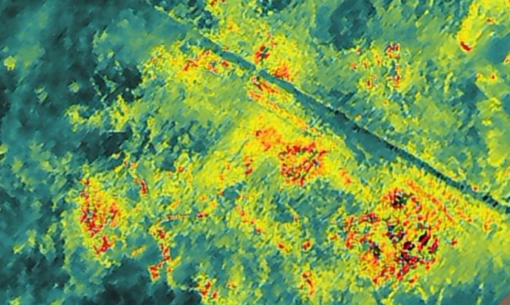
Multispectral NDVI Inspections
Normalised Difference Vegetation Index (NDVI) surveys can show how healthy a crop is, or areas where crops may need application of fertiliser or other action to maximise yield. We have provided these services to clients in agriculture, and on pitches at sports grounds & stadia, including the Premier League.
Thermal Inspections
We use the latest drone technology coupled with Forward Looking Infra-Red (FLIR) cameras to provide cutting edge survey and inspection services. This can assist with:
- Fire Spread Detection
- Photovoltaic Surveys
- Water Ingress Detection
- Heat Loss & Insulation Inspections
Photogrammetry Mapping
We provide professional aerial mapping and photogrammetry services for buildings and landscapes.
These can be used for a huge range of applications including providing essential coverage of locations or events, dealing with planning applications, managing natural disasters and environmental incidents, providing evidence at accident or crash sites, managing forestry, sandbanks, tidal areas, algae blooms, mapping geological areas of interest and identifying possible sites of archaeological interest.
We provide our maps in a variety of formats including Jpg, PDF, GeoTiff and formats to be imported into Google Earth, CAD and professional mapping programs. What use to take perhaps weeks of work by professional surveyors can now be done in one day.
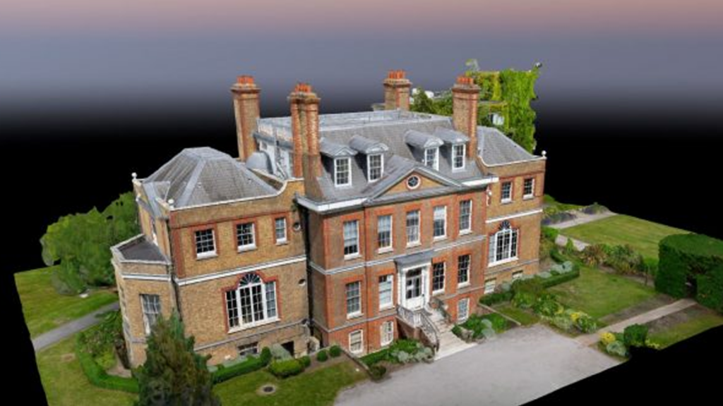
3D Modelling
We can deliver intricate, high quality, detailed, 3D models of a wide range of objects, surfaces, landscapes, buildings, and difficult to access areas. The output is a photo-realistic colour 3D model of the structure or site backed by a detailed ‘point cloud’ that can be imported into a professional mapping system. Tools online allow clients to view the structure from any angle, zoom in to look in high resolution detail at specific features, apply colour overlays for contours or showing vegetation or take a wide range of accurate measurements of sizes, distances, volumes of stock heaps etc.
These models are using extensively in a wide range of industries including:
- Mining– checking the structure and stability of mines, tips, structures.
- Industry– providing detailed images of plant and machinery and planning changes.
- Property Management– inspecting high rise buildings, checking the state of cladding and other features and examining roofs for damage, all for property management and insurance purposes.
OUR CASE STUDIES
Asset Inspections, Confined Space Inspections & Emergency Response
Department for Infrastructure / Rivers Agency
Since 2017 we have provided the Department for Infrastructure with asset inspections along their rivers to prevent risk to human inspection. This has also included confined space inspections and emergency call outs, such as to check culverts & drainage systems following major storms. With a guaranteed response time of under 2 hours,
NDVI Multispectral Inspection
Arsenal FC
We have been working with Arsenal groundskeepers since 2018 to help them manage the health of their pitches with our Multispectral NDVI drones. We provide them with a model of each pitch which enables them to identify grass health and conditions to focus their support to these areas. With minimal time onsite to capture the survey, this is a significant time saver and enables them to have the best pitch surfaces in the Premier League.
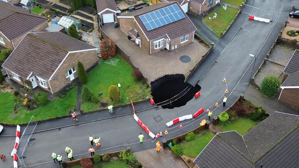
Confined Space Inspections, Thermal Surveys, 3D Modelling & Emergency Response
Mining Remediation Authority
(formerly The Coal Authority)
We support the Mining Remediation Authority through England, Scotland and Wales with a multitude of services. This includes responding to emergencies such as sink holes or landslides, 3D modelling coal seams on hillsides near homes and thermal surveys of unground seam fires. We have a contractual guaranteed response time which has always been met to even the most serious incidents and far-reaching locations.
3D BIM Modelling & Asset Inspection
Salix Homes
Following the tragic Grenfell tower block fire, all high-risk properties in the United Kingdom with similar cladding had to be inspected. We undertook BIM 3D Modelling of all high-rise blocks under the ownership or control of Sallix Homes including an asset inspection for any damage or defects in the cladding surface. As these blocks are private homes, a significant GDPR compliant procedure was followed to capture this and also ensure no persons or private areas could be identified in the survey files or resulting modelling. We also conduct a condition survey of any Salix Homes property annually for damage to roofs and guttering.
2D Mapping
Live Nation
We conduct 2D mapping of all Live Nation events to enable them to improve their planning, resilience and sustainability factors for future years. It also supports Event Control Rooms in responding to incidents faster.